Illustration
Introducing RE-FOCUS · The model for what already happened

The storm the record missed.

Before dawn on Saturday 9 August 2025 a storm crossed south-east Nebraska, and about 70,000 people woke up with no power. The global weather record caught none of it. RE-FOCUS rebuilt the night at 3 km, hour by hour, from what people saw.

Introducing RE-FOCUS

The model for what already happened.

RE-FOCUS is an AI weather model that rebuilds past storms at the scale they happened: hour by hour on a 3 km grid, anchored to the station readings and storm reports each storm left behind. It doesn't replace your risk model. It gives that model a sharper history of what happened.

3 kmThe grid: fine enough to hold a thunderstorm
HourlyGusts for every cell, hour by hour through the storm
20Versions of each storm, so you see the range

What it does

  1. 01Rebuilds the stormAn AI weather model redraws the event on a 3 km grid.
  2. 02Takes in the evidenceStation gusts and storm reports pull the storm to where they say it was.
  3. 03Keeps the rangeTwenty versions of the storm: the most likely gust and the spread around it.
  4. 04Hands over the footprintHourly gusts, cell by cell, in a standard gridded file.

What it's worth to you

  • Claims and event responseReserve and settle on what happened at the address.
  • Reinsurance and catCount the storms the record missed.
  • ParametricVerify the trigger on what the storm did at the site.

Here is one night it rebuilt.Watch the night →

The night, report by report

3:25 to 6:46 a.m.

The storm came in from the west before dawn and reached Omaha a little after six. Along the way, weather stations, storm spotters and emergency managers logged it as it passed. Here is every report, at the minute it was logged.

Clay CenterFairmontSewardCreteLincolnOmahaBlair
Measured gust, sized by speedDamage reported
6:46 a.m.Local time

    Every wind report NOAA's Storm Prediction Center logged in this area between 3 and 7 a.m., with the observers' own notes. Times are local.

    Illustration
    Lincoln Airport · 5:22 a.m.
    91mph

    Trees came down across Seward, Crete, Lincoln and west Omaha, on houses, cars and power lines. Barns and grain bins went in the fields between. By sunrise the storm was in Iowa.

    Illustration
    The morning after

    Then someone has to say what happened.

    Claims, reserves, recoveries and triggers all turn on the same thing: what the wind did at each place, and when. The place most people look first is the global weather record.

    The record

    The record caught none of it.

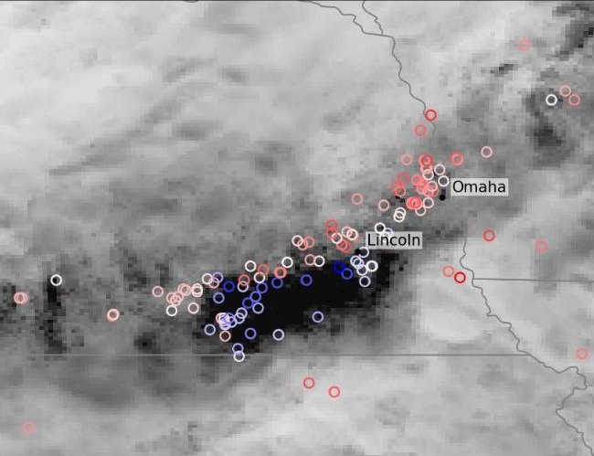
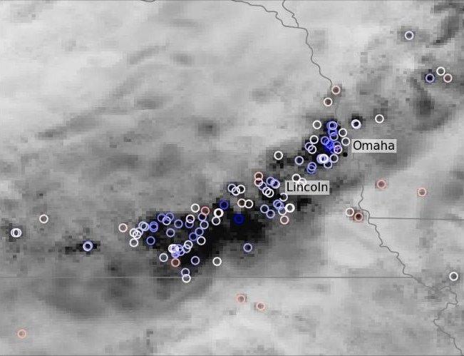
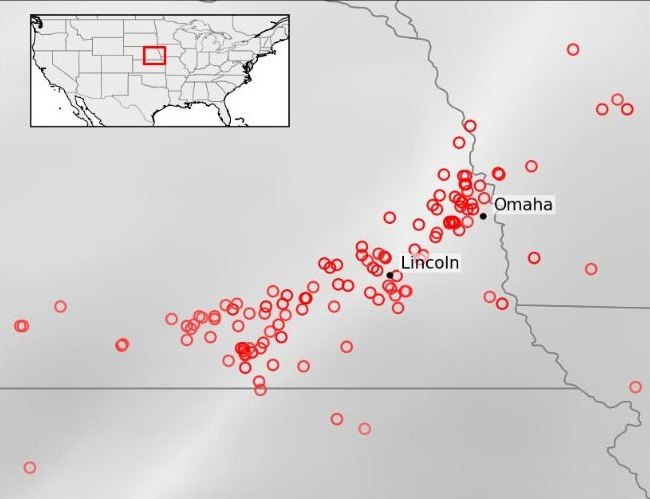
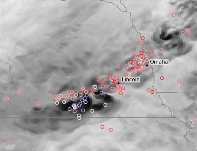
    The global weather record is drawn in squares about 31 km wide. A thunderstorm is a few kilometres across. Of the 121 extreme-gust reports that night, it caught none. Drag across the map to see the same night rebuilt.

    The global record's maximum gusts for the night: a smooth, featureless field, with every storm report marked red RE-FOCUS's rebuilt night: a dark band of damaging gusts from south-west of Lincoln to Omaha, with the storm reports sitting inside it
    The global record · 31 kmRE-FOCUS · 3 km

    Darker is a stronger gust. Circles are the storm reports: red where the record's gust was too low, blue where it was too high, white where it was close. The rebuilt night has the reports taken in.

    Filling it in

    How the night gets rebuilt.

    Four records of the same storm, each scored against the same 121 extreme-gust reports. A report counts as caught when the record's gust at that spot is within 15 mph of it.

    Twenty versions

    It runs as 20 versions of the storm, so you see the most likely gust and the spread around it.

    22 mph, not 50

    Its typical gust error before any reports went in, against 50 mph in the global record.

    The global record: the night's maximum gusts, with the storm reports markedNOAA's HRRR: the night's maximum gusts, with the storm reports markedRE-FOCUS, on its own: the night's maximum gusts, with the storm reports markedRE-FOCUS, with the reports taken in: the night's maximum gusts, with the storm reports marked
    Colour key: maximum gust in miles per hour from 0 to 80, and the error at each storm report from 40 mph too low to 40 mph too high

    The two-thirds is scored against the reports the run took in. Stations from ASOS, AWOS and METAR; the high-resolution model is NOAA's HRRR; the global record is ECMWF ERA5.

    The bottom line

    The public record missed every report that night. Rebuilt from what people saw, RE-FOCUS puts the storm back where it was.

    With and without RE-FOCUS

    The same night, scored against the same 121 reports.

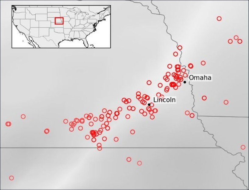
    Without RE-FOCUSThe public records The global record's maximum gusts for the night: a smooth, featureless field, with every storm report marked redThe global record · 31 km
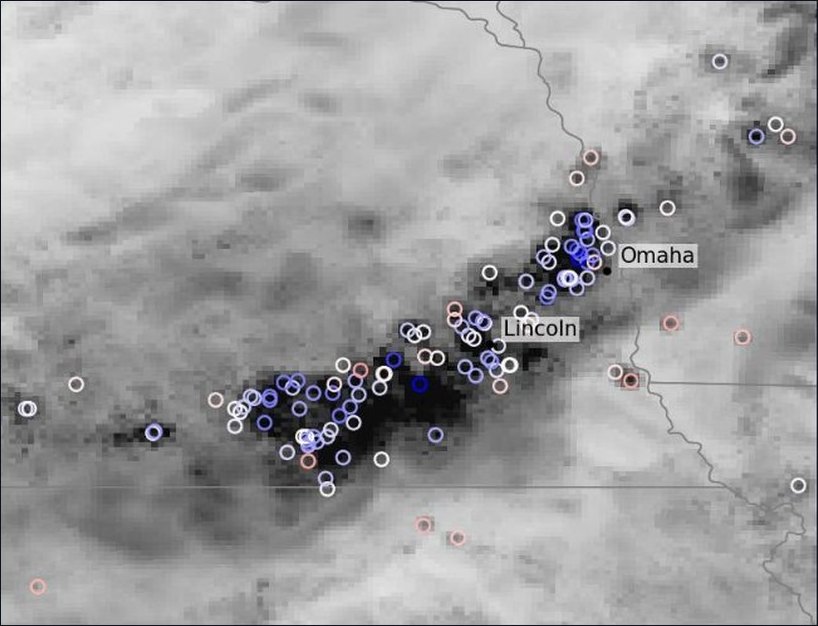
    With RE-FOCUSThe night, rebuilt RE-FOCUS's rebuilt night: a dark band of damaging gusts from south-west of Lincoln to Omaha, with the storm reports sitting inside itRE-FOCUS · 3 km, reports taken in
    Storm reports caughtof the 121 extreme-gust reports
    Without RE-FOCUS
    0%the global record
    11%NOAA's 3 km HRRR
    With RE-FOCUS
    25%on its own
    67%with the reports taken in
    Typical gust errorbefore any reports went in
    Without RE-FOCUS
    50 mphthe global record
    27 mphNOAA's 3 km HRRR
    With RE-FOCUS
    22 mphon its own
    Claims and event responseWhat did the wind do at this address, and when?
    Without RE-FOCUS

    The record has no storm at the address. What's left to reserve and settle on is a regional average.

    With RE-FOCUS

    An hourly gust record for every 3 km cell the storm crossed. Reserve and settle on what happened at the address, and size the loss while the claims are still coming in.

    Reinsurance and catDid our event history ever count a night like this?
    Without RE-FOCUS

    A night the record missed is a loss your event history never counted.

    With RE-FOCUS

    Check your event set against the storm as it actually happened. The rebuilt footprint lets you count it.

    ParametricWhat was the gust at the site, inside the contract's window?
    Without RE-FOCUS

    A wind trigger is only as good as the record it settles on, and this record never saw the storm.

    With RE-FOCUS

    Verify the trigger on what the storm did at the site, hour by hour, with the spread across 20 versions of the storm on the table for the basis-risk conversation.
    Single storms, rebuilt one at a time at 3 km and scored on gusts against storm reports and stations. The 67% is scored against the reports the run took in. They verify and settle events; they are not yet a multi-decade US wind record to price on.

    Illustration
    What you receive

    The night, cell by cell.

    Hourly gusts on the 3 km grid for every version of the storm, with the mean, the spread and the extremes, in a standard gridded file. It enters your model at the hazard step; vulnerability, terms and the model itself stay yours. Your model keeps its job. It gets a sharper history.

    Bring one event

    Every loss file has a night like this in it.

    A working session is an hour with the people who rebuild them, on an event you already know.

    1. 01You bring one storm from your loss file: the date, the area, and the record you used for it.
    2. 02We rebuild it at 3 km and compare both against the storm reports, the stations and your claims, on criteria we agree up front.
    3. 03You decide what's next.